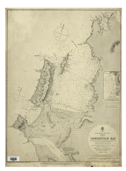
Concepcion Bay South America - West Coast, Chile [material cartográfico] : compiled from the partial surveys of various Officers of Her Majesty's Navy and from a French Government Chart of 1858.


Descripción Física
1 mapa : blanco y negro, montado en lienzo ; 64 x 47 cm, en hoja 69 x 50 cm.
Notas
General
Datos técnicos: Soundings in facthomes -- Fort Galvez Lat. 36°. 42'. O" S., Long. 73°. 6'. 45" W. -- Valparaiso (Fort St. Antonio) being 71°. 38'. 0" W.
En extremo inferior: Drawn by E. J. Powell, Hyd. : Off : under the direction of Captn. R. Hoskyn, R. N. Superintendent of Chart -- VIII-75. II-76. VIII-79. XII-79. III-82 -- Published at the Admiralty, 1st. July 1873, under the Superintendence of Rear Admiral G. H. Richards (George Henry Richards, 1820 - 1896), C. B., F. R. S., Hydrographer. Corrections Mar. 80 -- Engraved Davies & Company.
Contenido formateado
Inserto: Tomé Bay.
Forma física adicional disponible
Disponible en formato digital.
Reproducción
Reproducción electrónica. Santiago, Chile : Biblioteca Nacional de Chile, Laboratorio Digital, 2015. Objeto digital: MP0001600
Términos de uso y reproducción
Acceso en línea (dominio público) sin restricción de reproducción.
Referencia Bibliográfica
Concepcion Bay South America - West Coast, Chile / [material cartográfico] : compiled from the partial surveys of various Officers of Her Majesty's Navy and from a French Government Chart of 1858. London : Admiralty, 1st July 1873. [London] : [Admiralty], March 1882. 1 mapa : blanco y negro, montado en lienzo ; 64 x 47 cm, en hoja 69 x 50 cm. .
Clasificaciones
Colección: Mapoteca / Colección General
Materias: Cartas náuticas
Tipo de objeto: Material cartográfico
Año: 1882
Datos de publicación: London : Admiralty, 1st July 1873. [London] : [Admiralty], March 1882.
Tipo de acceso: Acceso en línea
BN Código: MP0001600
N° Sistema: 685662
BND id: 330149