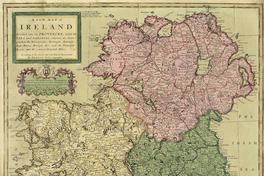
A New Map of Ireland divided into its provinces, counties and baronies, wherein are distinguished the Bishopricks, Borroughs, Barracks, Bogs, Passes, Bridges, &c. with the principal roads, and the common reputed miles [material cartógrafico] according to the newest and most exact observations by Herman Moll Geographer.


Descripción Física
1 mapa : color, montado sobre tela ; 104 x 63 cm.
Notas
General
Inserto de: descripción de la isla Purgatorio de San Patricio -- Un bosquejo del condado Cawsway en Antrim -- Plano de Waterford -- Plano de Gallway -- La bahía de Kingsale -- plano de Limrick -- Plano de Dublín -- Plano de Corke -- Catalogo de ciudades y lugares.
Referencia Bibliográfica
A New Map of Ireland divided into its provinces, counties and baronies, wherein are distinguished the Bishopricks, Borroughs, Barracks, Bogs, Passes, Bridges, &c. with the principal roads, and the common reputed miles [material cartógrafico] / according to the newest and most exact observations by Herman Moll Geographer. [London] : Printed for H. Moll over against Devereux Court in ye Strand, I. Bowles at the Black Horse in Cornhill, P. Overton map & printseller near St. Dunftns Church Fleetstreet, and T. Bowles print & mapseller next to the chapter house in st. Pauls church yard. And by I King Map & Printseller at the Globe in the Poultry, 1714. 1 mapa : color, montado sobre tela ; 104 x 63 cm. .
Clasificaciones
Autor: Moll, Herman, 1654?- 1732
Colección: Sala Medina / Mapas
Tipo de objeto: Material cartógrafico
Año: 1714
Datos de publicación: [London] : Printed for H. Moll over against Devereux Court in ye Strand, I. Bowles at the Black Horse in Cornhill, P. Overton map & printseller near St. Dunftns Church Fleetstreet, and T. Bowles print & mapseller next to the chapter house in st. Pauls church yard. And by I King Map & Printseller at the Globe in the Poultry, 1714.
Tipo de acceso: Acceso en línea
BN Código: SM0000684
N° Sistema: 1177514
BND id: 589403