Mapoteca / Colección General
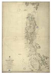
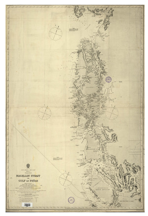
Magellan Strait to Gulf of Peñas South America - West coast : Sheet 2 Patagonia [material cartográfico] : compiled from Surveys by Captain [Phillip Parker] King, Comander [Pringle] Stokes and the Officers of H. M. S. Adventures & Beagle, 1828-30; Captain [Richard Charles] Mayne, C. B. and the Officers of H. M. S. Nassau, 1868-9; Lieutenant [Squire Thornton Stratford] Lecky, R. N. R. 1872-4; Captain Sir George Nares, K. C. B. and J. P. [John Pears...
Metadatos
- Título
- Magellan Strait to Gulf of Peñas South America - West coast : Sheet 2 Patagonia [material cartográfico] : compiled from Surveys by Captain [Phillip Parker] King, Comander [Pringle] Stokes and the Officers of H. M. S. Adventures & Beagle, 1828-30; Captain [Richard Charles] Mayne, C. B. and the Officers of H. M. S. Nassau, 1868-9; Lieutenant [Squire Thornton Stratford] Lecky, R. N. R. 1872-4; Captain Sir George Nares, K. C. B. and J. P. [John Pears...
- Tipo de acceso
- Acceso en línea
- Tipo
- Material cartográfico
- Datos de Publicación
- London : Admiralty, 1871. [London] : [Admiralty], September 1886.
- Descripción Física
-
1 mapa : blanco y negro, montado en lienzo ; 97 x 64 cm, en hoja 99 x 67 cm.
- Notas
-
General
En extremo inferior: Small corrections -- Drawn by E. J. Powell of the Hydrographic Office under the direction of Captn. Hoskyn, R. N. Supt. of Charts -- Superintendence of Captain G. H. Richard [George Henry Richard, 1820-1896], C. B.: F. R. S. Hydrographer -- Large corrections: November 1881, Septr. 1886 -- Engraved by Davies, Bryer & Co.
Forma física adicional disponible
Disponible en formato digital.
Reproducción
Reproducción electrónica. Santiago, Chile : Biblioteca Nacional de Chile, Laboratorio Digital, 2015. Objeto digital: MP0001549
Términos de uso y reproducción
Acceso en línea (dominio público) sin restricción de reproducción.
- Referencia Bibliográfica
-
Magellan Strait to Gulf of Peñas South America - West coast : Sheet 2 Patagonia / [material cartográfico] : compiled from Surveys by Captain [Phillip Parker] King, Comander [Pringle] Stokes and the Officers of H. M. S. Adventures & Beagle, 1828-30; Captain [Richard Charles] Mayne, C. B. and the Officers of H. M. S. Nassau, 1868-9; Lieutenant [Squire Thornton Stratford] Lecky, R. N. R. 1872-4; Captain Sir George Nares, K. C. B. and J. P. [John Pearse] Maclear and the Officers of H. M. S. Alert, 1879. London : Admiralty, 1871. [London] : [Admiralty], September 1886. 1 mapa : blanco y negro, montado en lienzo ; 97 x 64 cm, en hoja 99 x 67 cm. .
- Materia
- Cartas náuticas
- Años
- 1886
- Idioma
- eng
- Colección
- Mapoteca / Colección General
- BND Id
- 330145
- Códigos BN
- MP0001549
- Nº sistema
- 684478
- Miniatura